The Type of Faults

Due to the nature of world’s plates, Vancouver is a place where earthquakes can occur frequently. The lithospheric feature of British Columbia is complex while the North American continental plate has a single boundary with the Pacific plate and further north three small plates lie between these two major plates. Each of these plates is subducted below the less dense plate. The main reason why the Pacific Northwest is considered to be full of earthquakes is because it has transform, divergent and convergent convergent zones[1]. These zones can effectively contribute to the movement of plates and result in transform faults.
(1) Queen Charlotte Fault
The Queen Charlotte Fault is an active fault, located on the boundary of Pacific Ocean and North American plate. The Pacific plate and the North America plate are moving along each other and a subduction zone occurs. It is a result of a combination of reverse and strike-slip faulting, caused by a compression force between the two plates. It forms a triple junction on its south with the Cascadia subduction zone and the Explorer Ridge. The fault has been the focus of large earthquakes, like a magnitude 7 event in 1929, s magnitude 8.1 in 1949, a magnitude 7,4 in 1970 and a magnitude 7.7 on Oct 27th, 2012.
The Queen Charlotte Fault is an active fault, located on the boundary of Pacific Ocean and North American plate. The Pacific plate and the North America plate are moving along each other and a subduction zone occurs. It is a result of a combination of reverse and strike-slip faulting, caused by a compression force between the two plates. It forms a triple junction on its south with the Cascadia subduction zone and the Explorer Ridge. The fault has been the focus of large earthquakes, like a magnitude 7 event in 1929, s magnitude 8.1 in 1949, a magnitude 7,4 in 1970 and a magnitude 7.7 on Oct 27th, 2012.

Continental:Oceanic Convergent. Digital image. The Geosphere. N.p., n.d. Web. 8 Nov. 2015. <http://thegeosphere.pbworks.com/w/page/22058923/Plate%20Tectonics%20Final%20Map%20Project>.
(2)Rocky Mountain
The Canadian segment of the Rockies extends 1200km from the American borers of BC and Alberta. The Rockies form northwest-treading waves of sedimentary rock up-piled by vast thrust faults in the Tertiary age (65-1.65 million years ago) and eroded by glaciers. There are also many magnificent mountains formed[2].
The Canadian segment of the Rockies extends 1200km from the American borers of BC and Alberta. The Rockies form northwest-treading waves of sedimentary rock up-piled by vast thrust faults in the Tertiary age (65-1.65 million years ago) and eroded by glaciers. There are also many magnificent mountains formed[2].
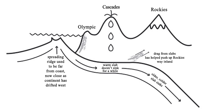
Rocky Mountain. Digital image. Geosciences E-Education. Penn State, n.d. Web. 8 Nov. 2015. <https://www.e-education.psu.edu/geosc10/l4_p3.html>.
(3) Cascade fault line
Cascadia starts from Cape Mendocino in California, extends through Oregon and Washington and ends in Vancouver Island in Canada. In the Cascadia subduction zone, the oceanic plate Juan de Fuca is sliding beneath the North American tectonic plate. If an earthquake occur between the magnitudes of 8,7 to 9.2 the ground will drop 6 feet at most and move 30 to 100 feet westward as the ground releases the tension it had been subjected to for centuries[3]. The fault line has a close relation to the Cascade volcanoes, which are created by the pushing of its active lava.
Cascadia starts from Cape Mendocino in California, extends through Oregon and Washington and ends in Vancouver Island in Canada. In the Cascadia subduction zone, the oceanic plate Juan de Fuca is sliding beneath the North American tectonic plate. If an earthquake occur between the magnitudes of 8,7 to 9.2 the ground will drop 6 feet at most and move 30 to 100 feet westward as the ground releases the tension it had been subjected to for centuries[3]. The fault line has a close relation to the Cascade volcanoes, which are created by the pushing of its active lava.
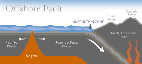
Offshore Fault. Digital image. Washington's Coast. Washington State Department of Ecology, n.d. Web. 8 Nov. 2015. <http://www.ecy.wa.gov/programs/sea/coast/waves/fault.html>.
There can exist a threat for a massive earthquake in the Pacific Northwest based on the previous research. According to the figure showing the recent earthquake magnitude, both of the Cascadia subduction zone and the Queen Charlotte fault are still capable of large earthquakes. As well as the Rocky Mountains still experience some small activity. Further on, the graph of the number of BC quakes per year since 1985 indicates that the number of earthquakes is steadily fluctuating. The main trend shows that there are continuous increasing small earthquake occur in this place during the past decade. These earthquakes which are below 6 can equate to a magnitude 9, causing tremendous damage to the local area[4].
The Possibility of a Massive Earthquake
There can exist a threat for a massive earthquake in the Pacific Northwest based on the previous research. According to the figure showing the recent earthquake magnitude, both of the Cascadia subduction zone and the Queen Charlotte fault are still capable of large earthquakes. As well as the Rocky Mountains still experience some small activity. Further on, the graph of the number of BC quakes per year since 1985 indicates that the number of earthquakes is steadily fluctuating. The main trend shows that there are continuous increasing small earthquake occur in this place during the past decade. These earthquakes which are below 6 can equate to a magnitude 9, causing tremendous damage to the local area[4].
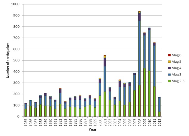
Dunning, Hayley, and Keith Rozendal. The Graph Showing the Number of B.C. Quakes per Year since 1985. Digital image. The Thunder Bird. UBC Journalism, 29 Mar. 2012. Web. 8 Nov. 2015. <http://thethunderbird.ca/2012/03/29/making-earthquake-predictions-for-b-c/>.
Current Earthquake Warning System in the Pacific Northwest
The Pacific Northwest Seismic Network system is a warning system for earthquakes in this area. It will issue an alert for any earthquakes above magnitude 3. Hundreds of seismometers around the Pacific Northwest will send readings to computers and analyzing the data and create an automated alert as quickly as four seconds after detecting quake activity.
It can be considered adequate because it uses the currently most advanced technology to detect seismic activities in the Pacific Northwest area. In 2013, it had issued a report warning that as many as 10,000 people could die[6]. However, its adequacy should still be taken in concern because it is a newly used system, and its data and previous achieves have not abundantly accumulated.
In British Columbia, there are many excellent organizations, which devote in raising public awareness (ex: shakedown BC and earthquake kites). In these plans, people can practice how to drop, cover and hold on during the drills. Their earthquake practices and preparations can inform people what they should do if there is a real one comes.
I think I am prepared for an earthquake because the school has practiced for earthquake for many times and I know what to do during an earthquake. However, I suppose that the authority should clearly distinguish the different preparedness planes of an earthquake and fire because currently the warnings for these two are quiet similar.
[1] Potter, Kate. "The Big One: Understanding Why The Big Earthquake Is Predicted for Vancouver." The Science Creative Quarterly. SCQ, 5 Nov. 2007. Web. 2 Nov. 2015. <http://www.scq.ubc.ca/the-big-one-understanding-why-the-big-earthquake-is-predicted-for-vancouver/>
[2] Grant, Peter. "Rocky Mountains." The Canadian Encyclopedia. Historica Canada, 16 Feb. 2009. Web. 04 Nov. 2015. <http://www.thecanadianencyclopedia.ca/en/article/rocky-mountains/%E2%80%98>.
[3] Gutierrez, Suzette. "Cascadia Fault Line: Scientists Predict Powerful Earthquake That Could Devastate The Pacific Northwest." Headlines Global News RSS. N.p., 16 July 2015. Web. 04 Nov. 2015. <http://www.hngn.com/articles/109826/20150716/cascadia-fault-line-scientists-predict-powerful-earthquake-devastate-pacific-northwest.htm>.
[4] Dunning, Hayley, and Keith Rozendal. "Earthquakes Are a Nearly Constant Feature of British Columbia." The Thunder Bird. UBC Journalism, 29 Mar. 2012. Web. 8 Nov. 2015. <http://thethunderbird.ca/2012/03/29/making-earthquake-predictions-for-b-c/>.
[5] Langer, Bernard. "Pacific Northwest Earthquake Threat Heightened?" Earth - The Science Behind the Headlines (2010): n. pag. Earth Magazine. American Geoscience Institute, Mar. 2010. Web. 8 Nov. 2015. <http://www.earthmagazine.org/article/pacific-northwest-earthquake-threat-heightened>.
[6] Cavaliere, Victoria, and Sandra Maler. "Earthquake Early Warning System Begins Testing in Pacific Northwest." Reuters. Ed. Daniel Wallis. Thomson Reuters, 17 Feb. 2015. Web. 08 Nov. 2015. <http://www.reuters.com/article/2015/02/17/us-usa-washington-earthquake-idUSKBN0LL26U20150217#mWpraGWY2cOG68Pu.97>.
 RSS Feed
